1885 >
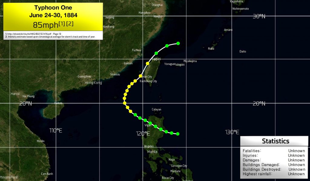
The origin of Typhoon One is unclear, as it was already a tropical storm on approach to the Philippines. It likely formed some days earlier to the southeast. After the storm passed over northern Luzon, it developed into a typhoon as it curved towards the north and then northeast towards Taiwan. HKO suggests that it maintained typhoon intensity until reaching the northern tip of Taiwan, when it weakened again. It likely turned post-tropical in the East China Sea.
This particular storm shows a curious profile, uncommon for June storms observed in modern times. Typically, there are two types of June storm in this area—significant typhoons which impact Luzon, weaken, and then move onto China or western Taiwan as a tropical storm or weaker typhoon (Percy 1990); or weaker tropical storms that form in the South China Sea and track northeast towards Taiwan (Talim 2012).
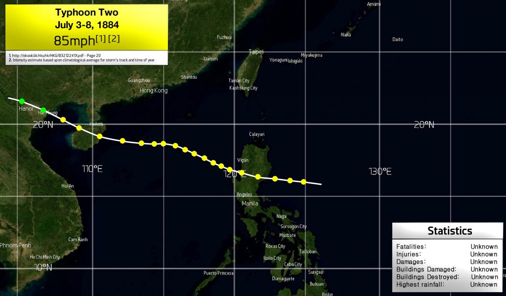
The second storm of the season was already of typhoon intensity when first detected on approach to Luzon on July 3rd. The typhoon likely retained its status over the Philippines, and may have been stronger upon landfall—Category 4 and 5 typhoons have been known to make landfall in this area in July. However, we expect that Typhoon Two behaved rather like Typhoon Eli (1992), which charted a similar track through the South China Sea, and was the only other July typhoon to strike that part of the Philippines and Hainan island.
HKO suggests that Typhoon Two maintained typhoon intensity into the Haiphong area of Vietnam and just north of Hanoi, though it’s more likely that the system weakened to a tropical storm by this point.
.
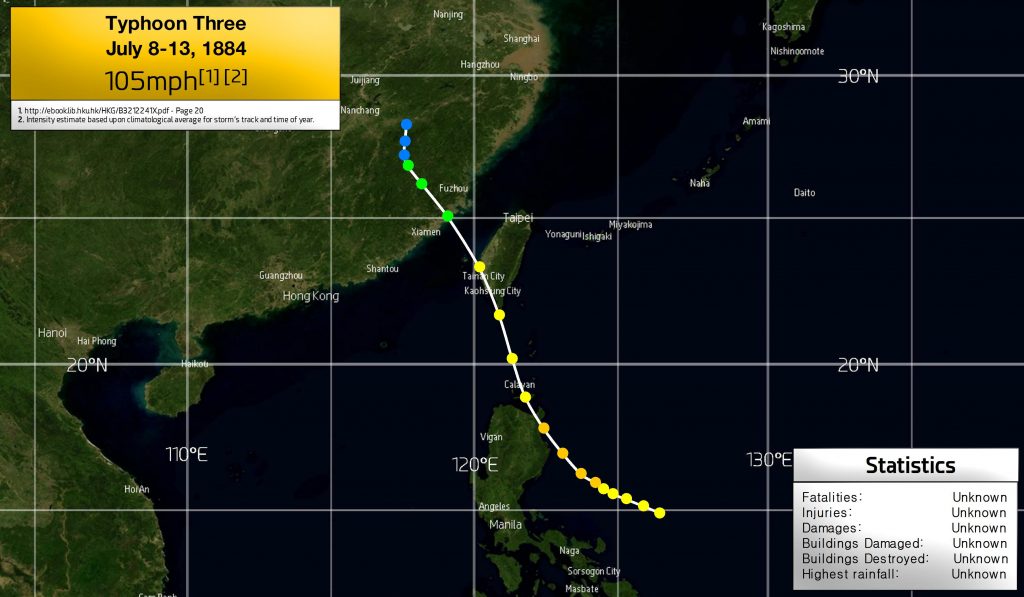
As Typhoon Two was dissipating over Vietnam, the third storm was detected approaching the Philippines at a somewhat lackadaisical speed, but accelerated significantly upon reaching Luzon, skimming the northeastern tip and moving on to Taiwan. A modern analog of this storm could be Typhoon Gloria of 1996, which struck Taiwan as a Category 2, however, given the Philippine landfall and fast pace, Typhoon Three likely weakened before reaching Taiwan and weakened further as it reached China before dissipating well inland.
.
.
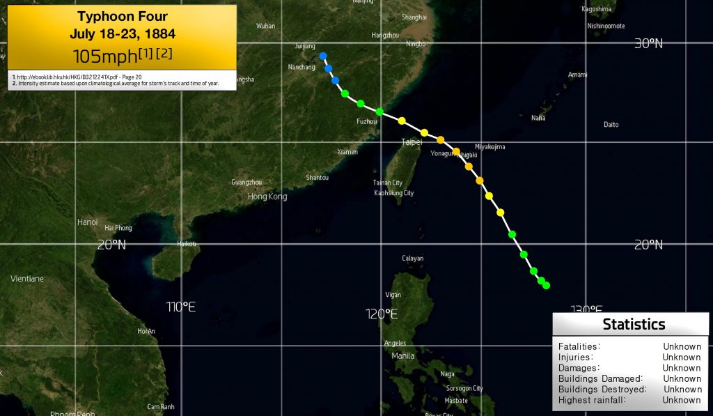
Less than a week after Typhoon Three, the fourth was detected as a tropical storm some 400 miles east of Luzon, and moved towards the northeast, becoming a typhoon on July 20th and likely peaking near the southern Ryukyu islands of Japan, and turning towards the west-northwest until its landfall north of Fuzhou, China. This typhoon may have been most similar to Billie (1959), until after its closest approach to Taiwan, in which the two storms’ paths diverge.
.
.
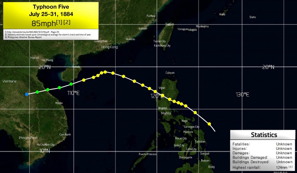
Typhoon Five was already a typhoon when first detected near Samar, Philippines, moving at a fast pace. The system either span up quickly near the islands, or formed closer to Palau and gained forward momentum before being detected. It is assumed that the typhoon maintained its status over its Luzon passage, and could have been stronger at landfall as well as over the South China Sea.
However, Typhoon Five turned towards the southwest and passed to the south of Hainan, continuing to travel west-southwest. No other July cyclone has ever been recorded to move in this direction. HKO suggests that Five remained a typhoon until landfall in Vietnam, but due to the unorthodox moment it is more likely that it lost intensity as it passed south of Hainan and reached Vietnam. Rainfall in the Philippines was reported to reach 124mm (4.9 in).
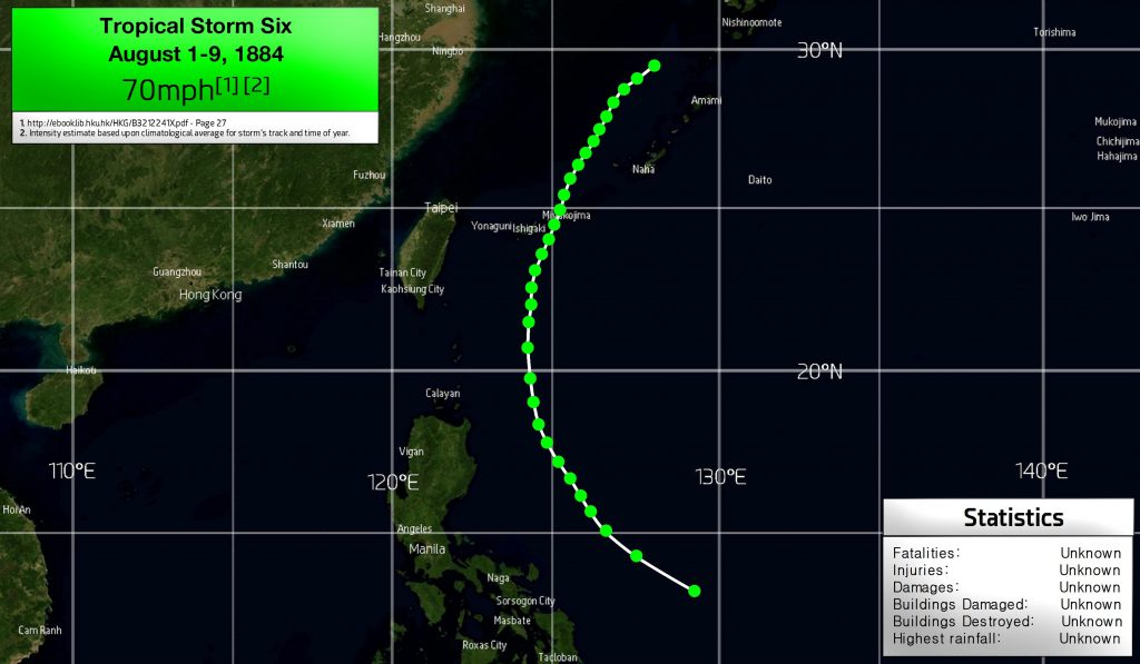
Tropical Storm Six formed in early August in the Philippine Sea, and recurved east of the Philippines towards the north, and then through the Miyako Islands of Japan. As it approached the islands and entered the East China Sea, the storm’s movement was noticeably slow, and it’s assumed that it turned post-tropical on the last track point displayed in the graphic. HKO suggests that the storm never reached typhoon status. Since there is no substantial evidence to the contrary, this is reflected in our reanalysis.
.
.
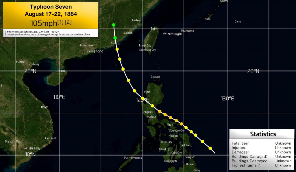
Typhoon Seven was first detected east of the Philippines at around 11 degrees north, already a typhoon. It is likely that it strengthened further and reached Category 2 intensity before landfall in the Philippines, grazing Catanduanes and Polillo islands before reaching Luzon and accelerating into the South China Sea.
This typhoon is the only August storm on record to impact this part of Luzon that went on to strike anywhere east of Hong Kong. All other storms impacted west of Hong Kong.
.
.
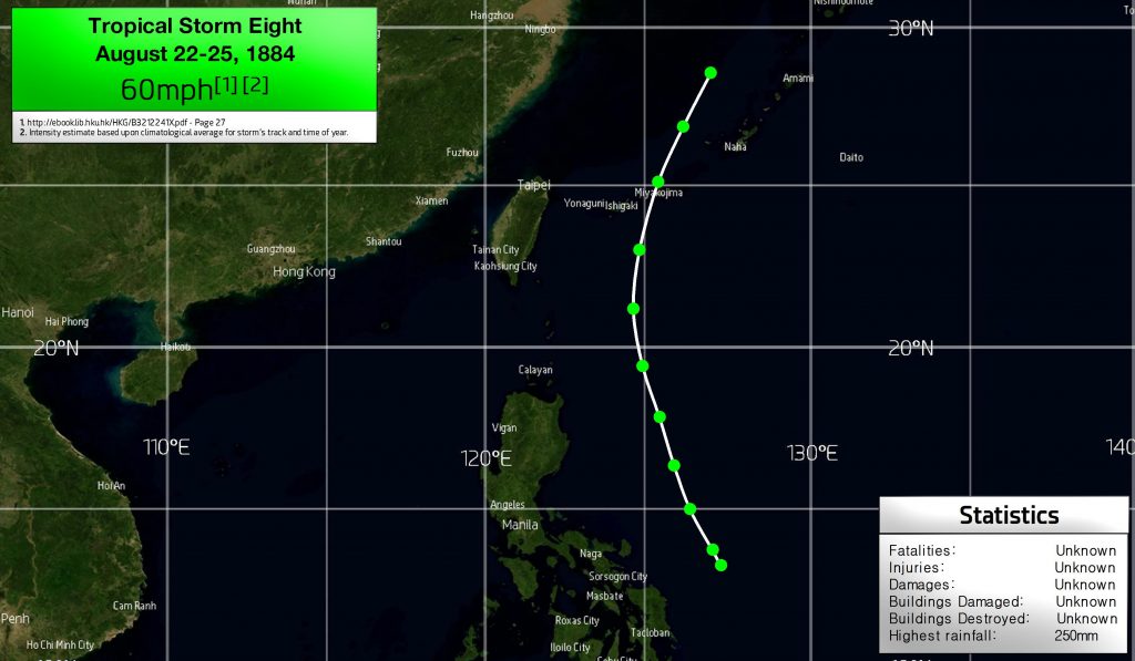
Tropical Storm Eight formed east of the Philippines in late August, and moved northwards at pace without intensifying beyond tropical storm status, as suggested by the HKO. The storm caused 250mm (9.8 in) of rainfall in Japan.
.
.
.
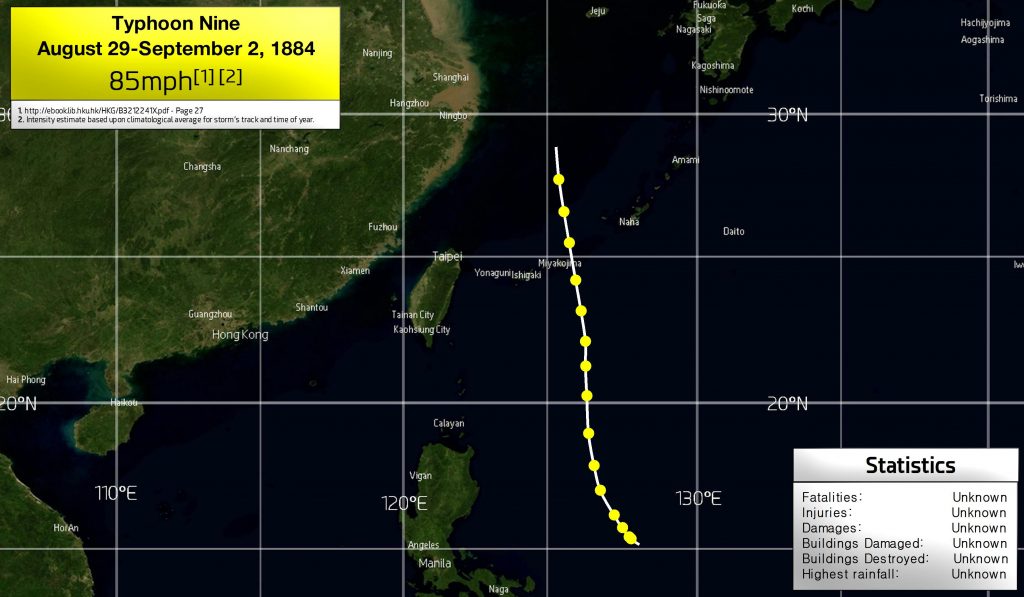
Typhoon Nine was detected several hundred miles east of the Philippines in late August, and moved generally towards the north. The intensity estimate is perhaps conservative and definitely uncertain, given that over 70% of August typhoons passing within 50 miles east of Miyakojima were of Category 2 intensity or higher, and over 80% of September typhoons passing within 50 miles east of Miyakojima were of Category 3 intensity or higher. The ultimate fate of Typhoon Nine is unknown. It is unlikely that it turned post-tropical immediately after the end of the known track, and probably approached South Korea or Japan as a transitioning typhoon.
.
.
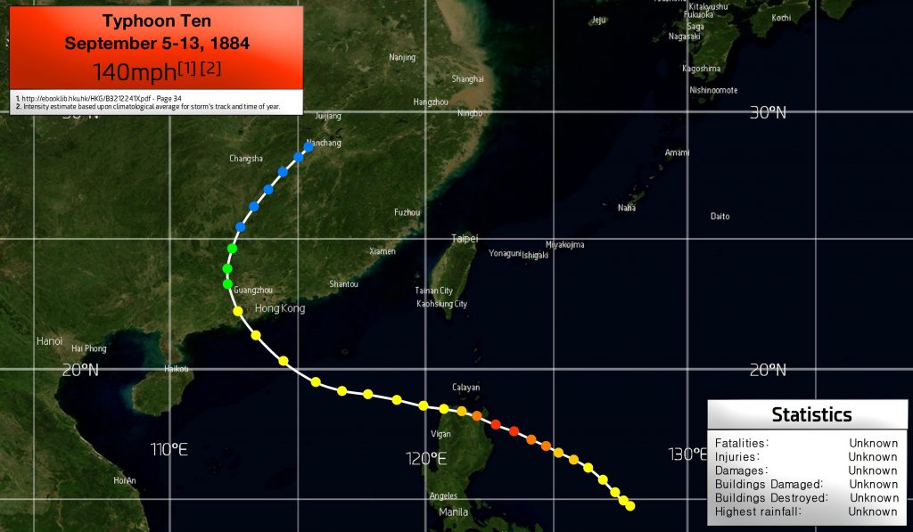
Typhoon Ten likely formed in the Philippine Sea, and was first detected moving slowly northwest as a typhoon. Whilst intensity estimates are unknown, it is a fair suggestion based upon September typhoon climatology that this storm likely intensified significantly and struck the northern tip of Luzon near Category 4 intensity, and maintained typhoon intensity into the South China Sea and to its landfall west of Macau. Ten then moved inland and curved towards the northwest, dissipating near Nanchang.
.
.

Typhoon Eleven was first noted around 200 miles from the Philippine islands, and probably reached Category 2 status as it passed the northeastern tip of Luzon and moved towards Taiwan, making landfall in the southwest of the island and paralleling the coast of China, probably weakening to a tropical storm and perhaps dissipating as it neared Ningbo. Alternatively, it may have remained stronger and turned post-tropical by this time.
.
.
.
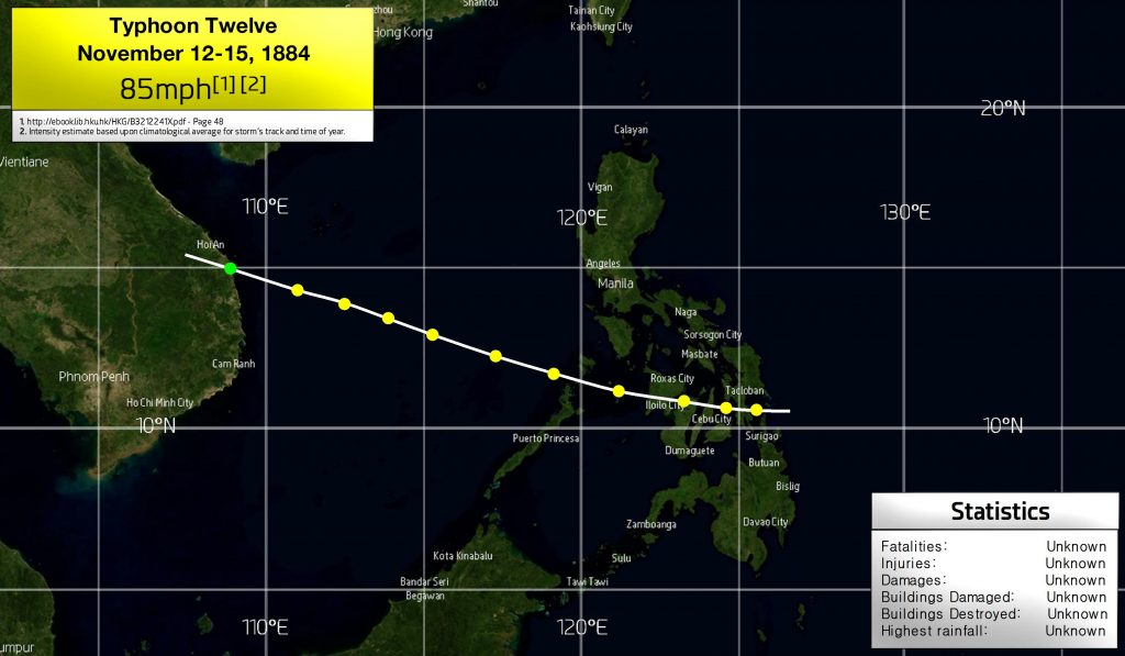
Typhoon Twelve was first observed making landfall on Leyte at an unknown intensity, and proceeding through Cebu, Negros and Panay islands before passing through Palawan and reaching Vietnam less than two days later. Due to the storm’s speed, it is listed as a Category 1 in our reanalysis, but it could possibly have been much stronger, like Agnes (1984).
.
.
.
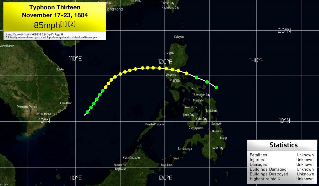
Tropical Storm Thirteen was reported to be developing 100 miles east of Catanduanes, Philippines, on November 17th. It likely reached typhoon status shortly before landfall in Luzon, and according to the HKO, retained typhoon intensity into the South China Sea and until dissipation. However, due to its southwestward curve, it is likely that the typhoon weakened as it sunk towards 10 degrees north and probably dissipated near the coast of southern Vietnam.
.
.
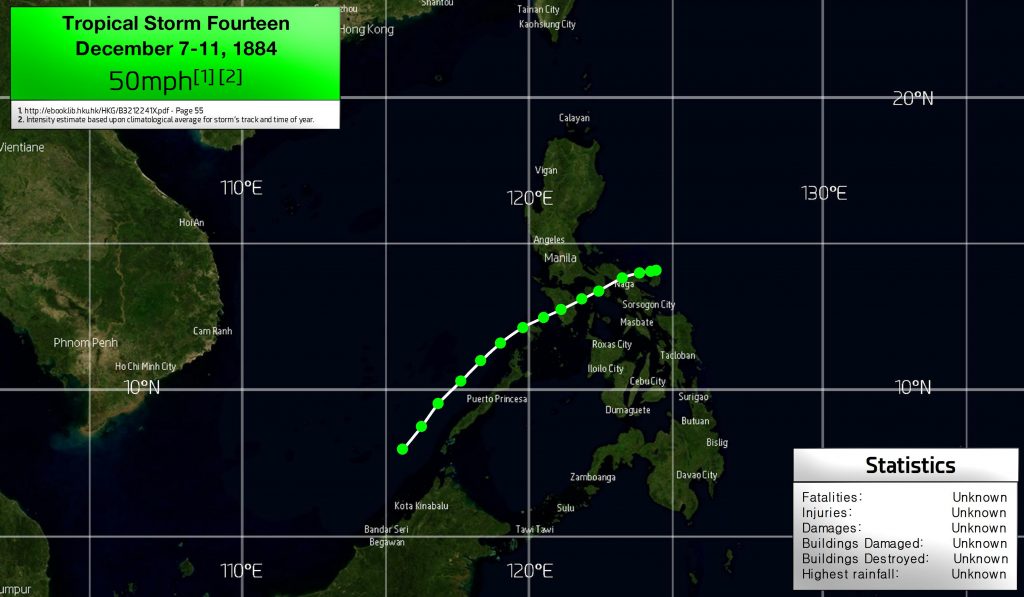
Tropical Storm Fourteen formed near Catanduanes, and projected an unusual southwesterly track for its whole duration, passing over Mindoro, and then following the western coast of Palawan until its assumed dissipation west of the southern tip of Palawan.
TS Fourteen was likely weak, possibly less than 50mph. Whilst not directly comparable with this storm, Typhoon Pamela of 1982 exhibited an even longer period of southwestward movement in December over the Philippines, in terms of distance travelled.